  | ||||||||||||||||||||||||||||||||||||||||||||
|
On Sunday, September 10, 2017 the eye of this Category 4 Cape Verde hurricane made landfall at Cudjoe Key in the Lower Florida Keys; later that day the center of Hurricane Irma made landfall at Marco Island in southwest Florida as a Category 3 hurricane.
Hurricane Irma September 2017 Crowdsource Photo Story Map
Click on HOME To Return To The Introduction
Most-recent images are at the top of the photo stream; you can use your computer's < and > arrows to move through the images. Click on an image and scroll up and down to view the photograph and read the poster's commentary with some including links to more information from news and other sources.
NASA/NOAA Earth At Night 2012
NOAA Satellite Reveals New Views of Earth at Night
"'For all the reasons that we need to see Earth during the day, we also need to see Earth at night,' said Steve Miller, a researcher at NOAA's Colorado State University Cooperative Institute for Research in the Atmosphere. 'Unlike humans, the Earth never sleeps.'"
"The day-night band observed Hurricane Sandy, illuminated by moonlight, making landfall over New Jersey on the evening of Oct. 29. Night images showed the widespread power outages that left millions in darkness in the wake of the storm. With its night view, VIIRS is able to detect a more complete view of storms and other weather conditions, such as fog, that are difficult to discern with infrared, or thermal, sensors. Night is also when many types of clouds begin to form."
USGS GEOMAC Wildfire Tracker and
Credits:
Credit: USGS Powered By ESRI
Credit: USGS
NOTE: Select MAP LAYERS > REAL-TIME DATA and check REAL-TIME STREAM GAGE to access details from the USGS National Water Information System
http://stn.wim.usgs.gov/fev/#HarveyAug2017
For More Information Visit:
https://www.usgs.gov/special-topic/hurricane-harvey
ICYN2K:
https://help.waterdata.usgs.gov/faq/surface-water/how-to-interpret-gage-height-and-streamflow-values
Credit: USGS
August 31, 2017
Katy, Texas – A team of canine search specialists from Nebraska Task Force 1 wait at the Base of Operations in Katy, Texas before being deployed on an urban search and rescue mission. FEMA supports federal agencies, the state, local communities, counties, volunteer agencies active in disaster and tribal entities in providing assistance to disaster survivors. Photo by Christopher Mardorf - Aug 31, 2017 - Location: Katy, TX
Credit: Photo by Christopher Mardorf / FEMA
August 31, 2017
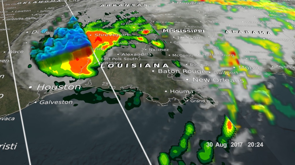
GPM caught Tropical Storm Harvey twice on August 30th, 2017. This time the storm made landfall in Louisiana and moved up east of the Texas/Louisiana border pounding already drenched eastern Texas and western Louisiana with more rain.
Credit:
NASA's Scientific Visualization Studio. GPM data provided by the joint NASA/JAXA GPM mission.
Data provided by the joint NASA/JAXA GPM mission.
Credit:
NASA's Scientific Visualization Studio. GPM data provided by the joint NASA/JAXA GPM mission.
Data provided by the joint NASA/JAXA GPM mission.
August 31, 2017
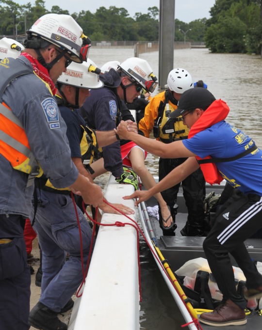
Members of FEMA's Urban Search and Rescue Nebraska Task Force One (NE-TF1) remove an survior from floodwaters in a neighborhood impacted by flooding from Hurricane Harvey
Photo by FEMA News Photo - Aug 31, 2017
Credit: Photo by FEMA News Photo - Aug 31, 2017
Released on August 30, 2017
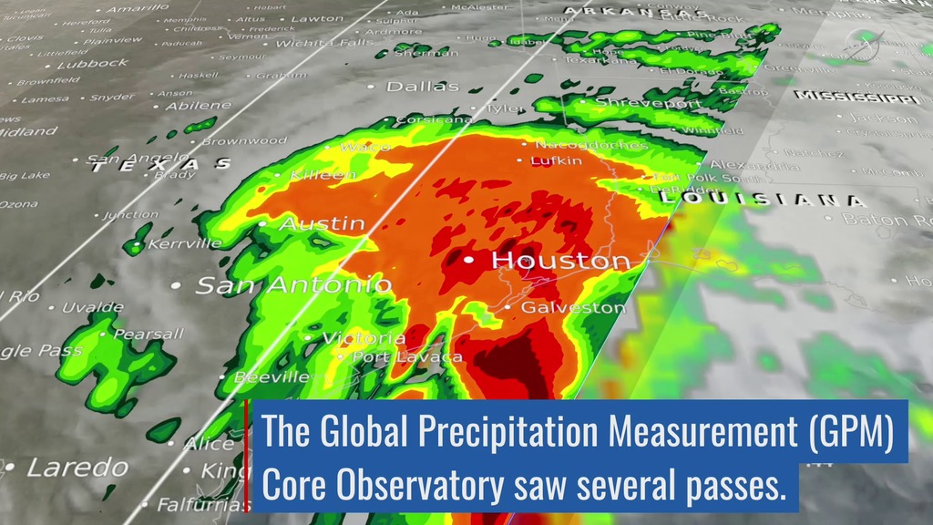
The Global Precipitation Measurement (GPM) Core Observatory captured these images of Hurricane Harvey at 11:45 UTC and 21:25 UTC on the 27th of August nearly two days after the storm made landfall as it was meandering slowly southeast at just 2 mph (~4 kph) near Victoria, Texas west of Houston. The image shows rain rates derived from GPM's GMI microwave imager (outer swath) and dual-frequency precipitation radar or DPR (inner swath) overlaid on enhanced visible/infrared data from the GOES-East satellite. Harvey's cyclonic circulation is still quite evident in the visible/infrared clouds, but GPM shows that the rainfall pattern is highly asymmetric with the bulk of the rain located north and east of the center. A broad area of moderate rain can be seen stretching from near Galveston Bay to north of Houston and back well to the west. Within this are embedded areas of heavy rain (red areas); the peak estimated rain rate from GPM at the time of this overpass was 96 mm/hr (~3.77 inches per hour). With Harvey's circulation still reaching out over the Gulf, the storm is able to draw in a continuous supply of warm moist air to sustain the large amount of rain it is producing.
Credit: NASA
Photo Credit:
August 30, 2017
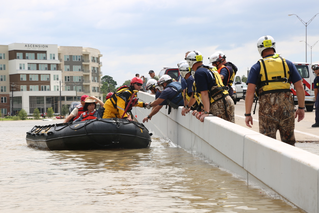
Members of FEMA's Urban Search and Rescue Nebraska Task Force One (NE-TF1) perform one of many water rescues in the aftermath of Hurricane Harvey.
Photo by FEMA News Photo - Aug 30, 2017
Credit: Photo by FEMA News Photo - Aug 30, 2017
August 28, 2017
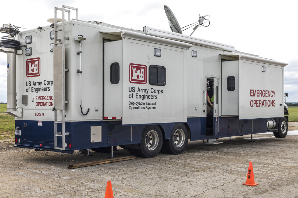
Seguin, Texas - A Deployable Tactical Operations System (contained in an Emergency Operations vehicle) of the U.S. Army Corps of Engineers pre-positioned to deploy from an Incident Staging Base (ISB) at Robinson Air Force Base in Seguin, Texas, in response to Hurricane Harvey which received a major disaster declaration on August 25, 2017. FEMA supports federal agencies, the state, local communities, counties, volunteer agencies active in disaster and tribal entities in providing assistance to disaster survivors.
Photo by Christopher Mardorf - Aug 28, 2017 - Location: Seguin, TX
Credit: Photo by Christopher Mardorf / FEMA.
August 27, 2017
MREs at FEMA's Fort Worth, Texas Logistics Center are ready for loading onto trailers bound for Hurricane Harvey survivors.
Photo by Photo by Earl Armstrong - Aug 27, 2017
Credit: Photo by Earl Armstrong / FEMA
Event Date August 21, 2017;
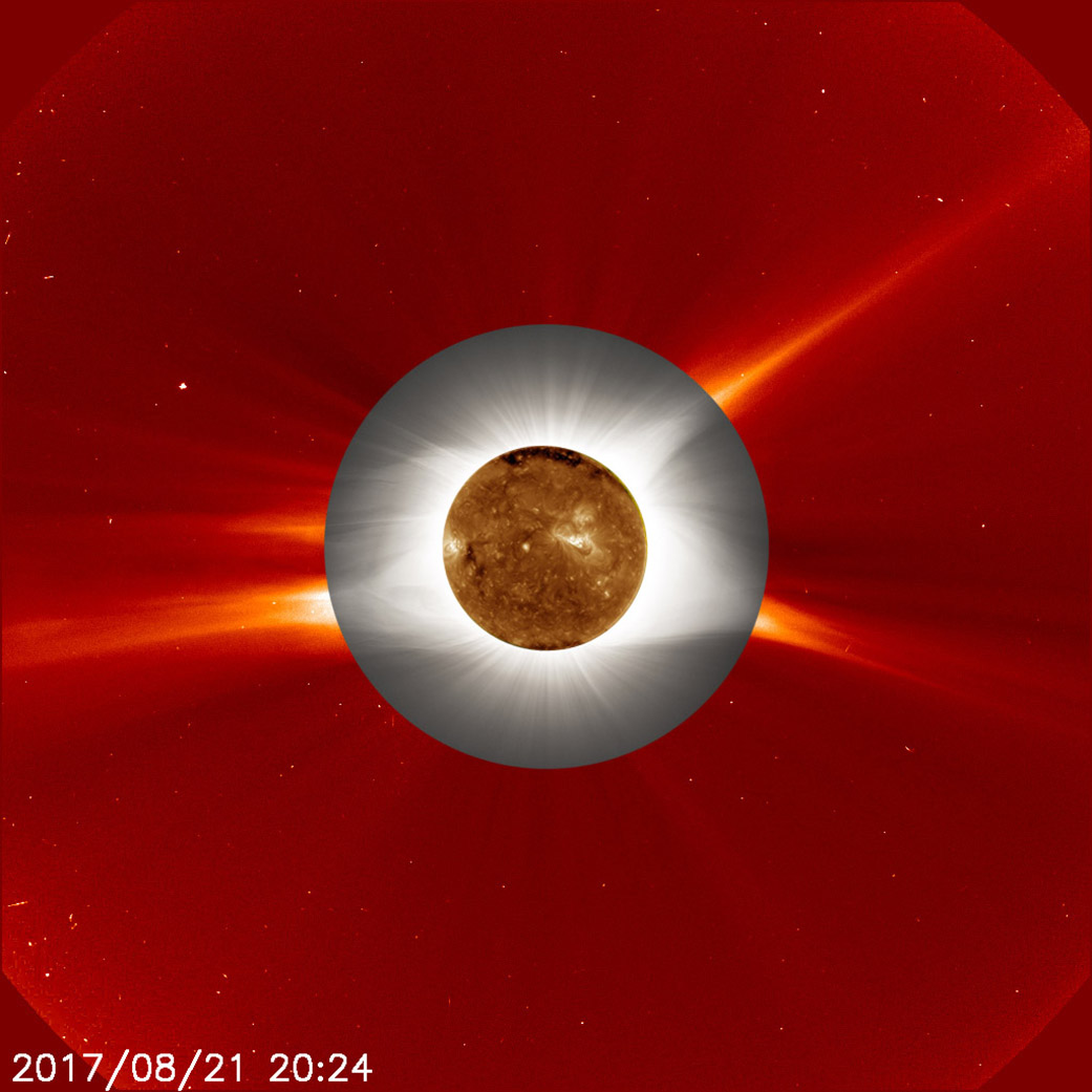
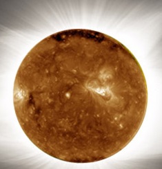
A ground-based image of the total solar eclipse on Aug. 21, 2017 (gray, middle ring), is superimposed over an image of the Sun's atmosphere, called the corona (red, outermost ring), as seen by ESA (the European Space Agency) and NASA's Solar and Heliospheric Observatory (SOHO), which watches the Sun from space. At center is an image of the sun's surface as seen by NASA's Solar Dynamics Observatory in extreme ultraviolet wavelengths of light.
During a total solar eclipse, ground-based telescopes can observe the lowest part of the solar corona in a way that can't be done at any other time, as the dim corona is normally obscured by the bright light of the Sun. The structure in the ground-based corona image – defined by giant magnetic fields sweeping out from the Sun's surface &8211; can clearly be seen extending into the outer image from the space-based telescope. The more scientists understand about the lower corona, the more they can understand what causes the constant outward stream of material called the solar wind, as well as occasional giant eruptions called coronal mass ejections.
Innermost image: NASA/SDO
Ground-based eclipse image: Jay Pasachoff, Ron Dantowitz, Christian Lockwood and the Williams College Eclipse Expedition/NSF/National Geographic
Outer image: ESA/NASA/SOHO
Credit: NASA's Goddard Space Flight Center
https://svs.gsfc.nasa.gov/cgi-bin/details.cgi?aid=12704
For More Information On The Critical Importance Of Understanding The Impacts Of Solar Natural Phenomena Here On Earth, Please Visit https://geomag.usgs.gov/:
"While major geomagnetic storms are rare, with only a few recorded per century, there is significant potential for large-scale impacts when they do occur. Extreme space weather can be viewed as hazards for the economy and national security.
"The entire Canadian province of Quebec, which covers twice as much area as the State of Texas, was plunged into darkness on the morning of March 13, 1989. An intense geomagnetic storm seized Quebec's power-grid system, tripping relays, damaging high-voltage transformers, and causing a blackout.
"This geomagnetic storm's impact on Quebec pales in comparison to what could happen in the future. A report by the National Academy of Sciences suggests that a rare but powerful magnetic superstorm could cause continent-wide loss of electricity and substantial damage to power-grid infrastructure that could persist for months and cost the Nation in excess of $1 trillion.
"'Utility groups rely on historical data collected by long-running USGS [U.S. Geological Survey] magnetic observatories to see what a worst-case scenario could look like,' said Mark Olson, a standards developer with the North American Electric Reliability Corporation (NERC). 'These data help NERC draft standards aimed at maintaining reliable operations of the North American power grid.'
"...When a large sunspot emerges, the likelihood of an abrupt emission of radiation and an intense solar wind becomes greater. When these winds reach the Earth, electrically charged particles enter the Earth's magnetosphere, ionosphere, and interior, inducing a geomagnetic storm. The storm can interfere with utilities, infrastructure, and technologies essential to modern society, disrupting daily life, the economy, and national security."
Preparing the Nation for Intense Space Weather
Photo Credits:
Event Date August 21, 2017;
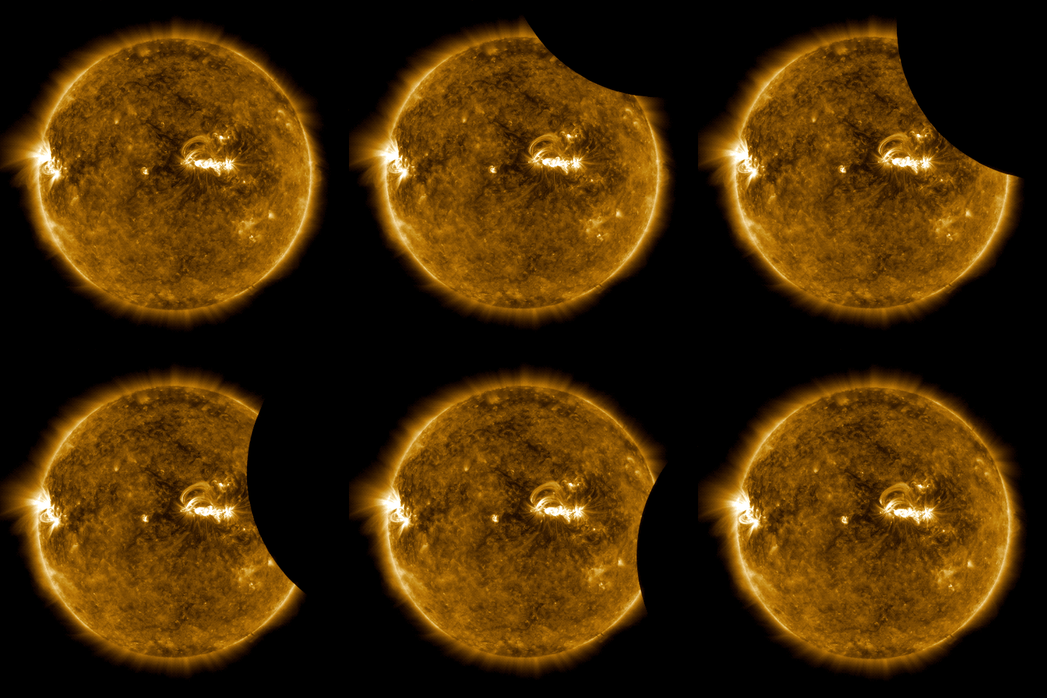
NASA's Solar Dynamics Observatory was also treated to a view of the Moon blocking the Sun. Because of its location 3,000 miles above the Earth, SDO sees several lunar transits each year. An eclipse on the ground, however, does not guarantee that SDO will see anything out of the ordinary. In this case, SDO was lucky and got treated to the Moon briefly passing in front of its non-stop view of the Sun at the same time that the Moon’s shadow passed over the eastern United States. SDO only saw 14% of the Sun blocked by the Moon, whereas most US residents saw 60% or more.
Launched on Feb. 11, 2010, the Solar Dynamics Observatory, or SDO, is the most advanced spacecraft ever designed to study the Sun. It has examined the Sun's atmosphere, magnetic field and also provided a better understanding of the role the Sun plays in Earth's atmospheric chemistry and climate. SDO captures images of the Sun in 10 different wavelengths every 12 seconds at resolution 8 times better than HD. Each wavelength helps highlight a different temperature of solar material. Different temperatures can, in turn, show specific structures on the sun such as solar flares, which are gigantic explosions of light and x-rays, or coronal loops, which are stream of solar material traveling up and down looping magnetic field lines.
Credit: NASA
Photo Credit: NASA
Released on October 24, 2014; Updated October 28, 2014
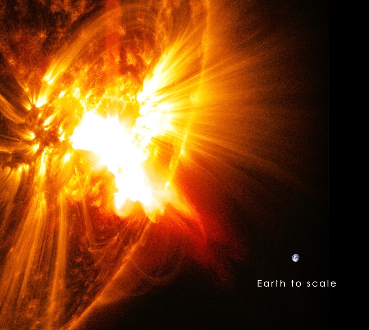
The sun emitted a significant solar flare, peaking at 5:40 p.m. EDT on Oct. 24, 2014. NASA's Solar Dynamics Observatory, which watches the sun constantly, captured images of the event. Solar flares are powerful bursts of radiation. Harmful radiation from a flare cannot pass through Earth's atmosphere to physically affect humans on the ground, however -- when intense enough -- they can disturb the atmosphere in the layer where GPS and communications signals travel.
This flare is classified as an X3.1-class flare.
X-class denotes the most intense flares, while the number provides more information about its strength. An X2 is twice as intense as an X1, an X3 is three times as intense, etc.
The flare erupted from a particularly large active region -- labeled AR 12192 -- on the sun that is the largest in 24 years. This is the fourth substantial flare from this active region since Oct. 19.
The giant active region on the sun erupted on Oct. 26, 2014, with it's sixth substantial flare since Oct.19. This flare was classified as an X2-class flare and it peaked at 6:56 am EDT.
Continuing a week's worth of substantial flares beginning on Oct.19, 2014, the sun emitted two mid-level solar flares on Oct. 26 and Oct. 27. The first peaked at 8:34 pm EDT on Oct. 26, 2014, and the second peaked almost 10 hours later at 6:09 am EDT on Oct. 27. NASA's Solar Dynamics Observatory, which constantly observes the sun, captured images of both flares.
A large active region on the sun erupted with another X-class flare, an X2.0, on Oct. 27, 2014 -- its fourth since Oct. 24. The flare peaked at 10:47 a.m. EDT.
The sun emitted a mid-level solar flare, an M6.6-class, peaking at 11:32 pm EDT on Oct. 28, 2014
Photo Credit: NASA
https://svs.gsfc.nasa.gov/cgi-bin/details.cgi?aid=11718
Credit: NASA/GSFC/SDO
Photo Credit: NASA
For comprehensive news coverage, visit these websites:
Newspapers
Radio & Television Stations
WNYC
|
||||||||||||||||||||||||||||||||||||||||||||
All Contents Copyright 2000 and Beyond PrepareRespondRecover.com.
No material may be reprinted, republished or redistributed All logos, servicemarks and trademarks are the property of their respective owners. .
|
||||||||||||||||||||||||||||||||||||||||||||


